
QUICK INDEX OF TOPICS ON THIS PAGE:
- OUR METHOD
- OUR PROPOSED ROUTE: 3 MINI-TOURS
- MAPS (INTERACTIVE & DOWNLOADABLE)
- ALTERNATIVE GROUND TRAVEL
- ROUTE DETAILS CHART
DOWNLOAD our ROUTE DETAILS CHART PDF for day-to-day list of information.
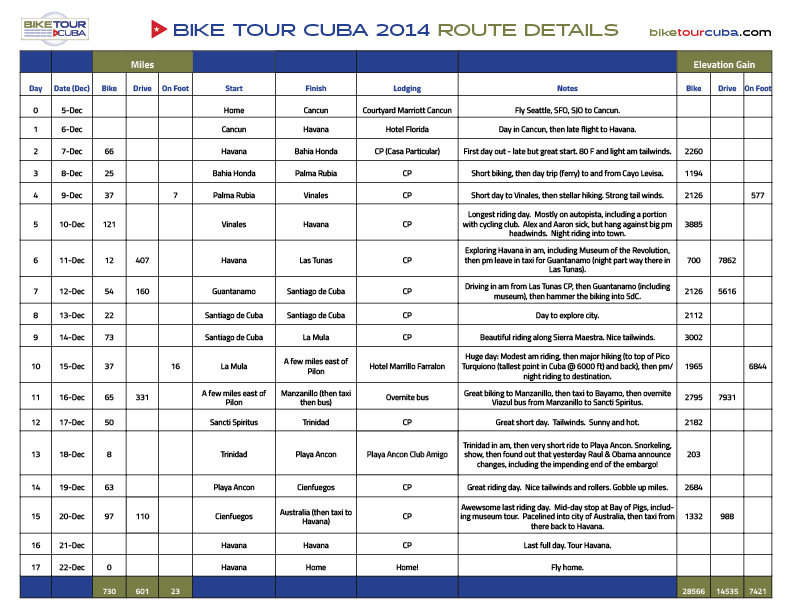
Click on this image to download the ROUTE DETAILS CHART as a PDF document.
Route Planning & Maps
Our method
We started at square one. Armed with several travel Cuba books, the internet and big maps stuck up on the wall, we all started trying to figure out where we wanted to go. Our timeframe was limited to 17 days in December so the question became, “Within that time, what are the places would we most like to see and how can we link them together most efficiently”?
When we looked at our list of places and considered likely wind direction, milage, and other factors, a “three mini tours” route idea was born. We’d basically divide the riding into three sections and then somehow (to be determined no later than the last minute) hop ahead to the next section. As much as possible, we would generally plan to bike in an East to West direction to try and take advantage of the prevailing winds that blow across the island that time of year. It seemed like a good plan if we could stick to it and get through all the off-bike travel days without major complications or delays. In Cuba that would prove to be a lot to hope for.
Our Proposed Route:
3 Mini-Tours
MINI-TOUR 1. After arriving in Havana we’d begin by riding west along the north coast toward Vinales National Park for three days and then ride a long day, 100 miles minimum, inland back toward Havana on day 4.
MINI-TOUR 2. From Havana we planned to get (bus, train, car, plane?) to the other end, the southeastern part, to Guantanamo and possibly as far as Baracoa. From there we would bike back from the east through Santiago de Cuba, and then along the south coast where the Sierra Maestra mountain range rises up from the Carribbean Sea. We would ride past Pico Turquino, the highest point in Cuba (and if possible, we might try to climb it, without bikes) and then continue along the southern coast until it turned north up to Manzanillo.
MINI-TOUR 3. From Manzanillo we would need to somehow get to Bayamo, where we knew we should be able to catch a Viazul bus heading northwest back to Sancti Spiritus for the beginning of the third “mini-tour” or our trip. From Sancti Spiritus we planned to ride down to historic Trinidad and Playa Ancon on the central south coast and then continue biking west to Cienfuegos and along the Bahia de Cochinos (Bay of Pigs) to Playa Larga which would put us within a day’s ride to Havana, our final destination.
The proposed route hit most of the spots we wanted to see and seemed like a good compromise of mostly biking days, a couple of non-bike travel days to connect the segments, and a couple of “rest” days to enjoy along the way when we found a place we’d like to stay a little longer.
(For more detailed info, DOWNLOAD a PDF document of our ROUTE DETAILS CHART.)

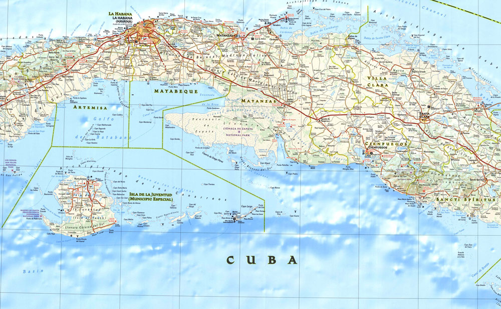
Maps
We've provided helpful maps in two forms here:
1. Interactive maps viewable online using the links below.
2. Downloadable map image files that can be stored on your own devices.
INTERACTIVE MAPS
- This will link you to view our interactive route overview: View Interactive Route Overview
- This will link you to a detailed interactive route with basic descriptions of each day: View Interactive Route With Descriptions of Each Day
DOWNLOADABLE MAPS
TPC-J-26A (Tactical Pilotal Chart):
- Small Map JPEG = 1500px x 1092px (704 kb)
- Medium Map JPEG = 3000px x 2185px (2.7 mb)
- Large Map JPEG = 17,520px × 12,712px (15.1 mb)
- Map as PDF = (6.4 mb)
TPC-J-26B (Tactical Pilotal Chart):
- Small Map JPEG = 1500px x 1092px (732 kb)
- Medium Map JPEG = 3000px x 2185px (2.7 mb)
- Large Map JPEG = 17,424px × 12,688px (12.8 mb)
- Map as PDF = (6.3 mb)
Cuba International Travel Map 1
- Small Map JPEG = 1500px x 1044px (535 kb)
- Large Map JPEG = 17,796px x 8208px (10.2 mb)
- Map as PDF = (4.4 mb)
Cuba International Travel Map 2
- Small Map JPEG = 1500px x 1044px (428 kb)
- Large Map JPEG = 17,796px x 8208px (8.4 mb)
- Map as PDF = (4 mb)
Adventure Travel Map 1
- Small Map JPEG = 1500px x 1018px (432 kb)
- Large Map JPEG = 11,388px x 7728px (5.5 mb)
- Map as PDF = (2.7 mb)
Adventure Travel Map 2
- Small Map JPEG = 1500px x 1018px (469 kb)
- Large Map JPEG = 11,388px x 7728px (6.1 mb)
- Map as PDF = (2.6 mb)
Tourist Map of Cuba 1
- Medium Map JPEG = 3000px x 2013px (1.9 mb)
- Large Map JPEG = 7488px x 5024px (3.9 mb)
- Map as PDF = (1.3 mb)
Tourist Map of Cuba 2
- Medium Map JPEG =3000px x 2017px (1.2 mb)
- Large Map JPEG = 7437px x 5000px (3.9 mb)
- Map as PDF = (1.5 mb)
Maps by Days:
1. Havana to Bahia Honda
2. Bahia Honda to Cayo Levosa
6.1 Drive Las Tunas to Guantanamo
7.1 Santiago de Cuba tour Aaron
8.1 La Mula to Pico Turquino trailhead
8.3 Pico Turquino trailhead to Hotel Farallon
9.1 Drive Manzanillo to Sancti Spiritus
Alternative Ground Travel
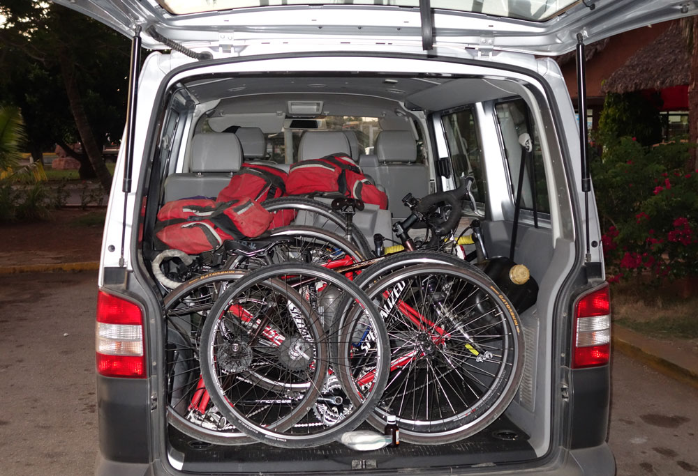
Our route required hiring a car to drive us from Havana to Guantanamo, about 565 miles -- most of the length of the country. Our original plan was to take a Viazul bus for this part of the trip, but upon arriving at the Viazul terminal in Havana we found out there were no available seats for the next four days. The Viazul bus ticket from Havana – Santiago de Cuba would’ve been about $50/person.
VIAZUL BUSSES. Viazul busses are the “nice” busses in Cuba, the ones primarily used by tourists. They run regularly throughout the country and are a good way to get to most of the major tourist destinations and larger cities. And for a small surcharge you can load your bikes into the cargo hold underneath. Fairly clean, fairly reliable. Very few Cubans can afford the Viazul bus fares so they are almost exclusively used by foreign travelers. Upon discovering the Viazul busses were full for the next several days, we went outside the bus terminal and began talking to the assemblage of taxi drivers waiting out front. Would anyone be interested in driving us to Guantanamo? Hard to imagine hiring a taxi in the US to drive 565 miles, but in Cuba, no problem.
After some negotiation we agreed to pay a professional driver $300 to pick us up at our hotel in Havana Vieja that afternoon and drive us, our bikes and bags, overnight to Guantanamo in a VW Eurovan. A cash deposit was paid to the driver when he arrived and the balance, as well as a generous tip, was paid when we arrived in Guantanamo. Our driver, Abel, was the consummate professional and ended up meeting us again at the very end of our bike ride for an unforgettable celebration that just by chance happened to end at a huge street carnival. Anything goes in Cuba and if you can find someone with a car, taxi driver or otherwise, you may be able to procure a ride for a small price.
HITCHHIKING. Although we never did it, and I doubt they even think of it as hitchhiking, trying to catch a ride from any passing vehicle seems to be commonplace in Cuba. So few people have private cars that roadsides are filled with people walking along or just standing on the roadside waving (sometimes with pesos in hand) at passing vehicles, hoping to catch a ride. Trucks, tractors pulling trailers, busses, cars, horse-drawn carts, pedal carts– all are viable options for catching a ride in Cuba.
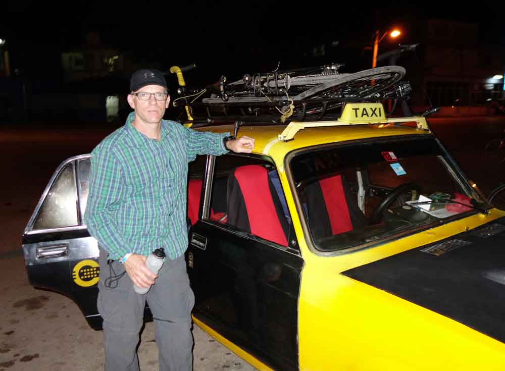
TAXI. At the end of the second leg or our trip, we arrived in Manzanillo at sunset and needed to hire a taxi to take us the 30 or so miles to Bayamo to catch an overnight bus west. After talking with several taxi drivers we found a guy with a 1982 Russian Lada to let us strap the bikes on the roof and cram in for the hour long ride. I think we gave that guy $30 for the hour long ride but the most memorable part was holding our little USB rechargeable bike lights out the car window to help light up the road for the driver.
We did take the Viazul bus later in the trip from Bayamo to Sancti Spiritus. That was a scheduled 8 hour bus ride that, including multiple middle of the night, middle of nowhere breakdown stops, and an out-of-order bathroom, ended up taking about 12 hours. $21. Lifelong memories of that overnight sleepless busride –priceless.
(For more info, see our FAQs page.)